Mill Record Stamford
RETURN TO ‘FIND MILLS’Disclaimer: Content for these properties was compiled in 2014-2017 from a variety of sources and is subject to change. Updates are occasionally made under Property Information, however the Connecticut Trust for Historic Preservation (dba Preservation Connecticut) makes no representation or warranty that the information is complete or up-to-date.
- Complex Name (Common)
- Charles H. Phillips Chemical Co.
- Complex Name (Historic)
-
- Charles H. Phillips Chemical Co.
- Address or Location
- 650, 668 Glenbrook Road, Glenbrook, Stamford
- County
- Fairfield
- Historic Designation
- Associated Mill Community
- n/a
 What can you do at this mill?
- Historic Information
Companies Associated w/Complex
- Charles H Phillips Chemical Co. 1885-1923
- Charles H Phillips Co. (Div. of Sterling Drug Inc.) 1923-1976
- Phillips Camphor and Wax Co. 1849-1885
Use (Historic)
Largest Documented Workforce
n/a
Historic Narrative
The Phillips Camphor and Wax Company is historically significant as one of Stamford’s earliest industries that produced one of its most famous products, Phillips Milk of Magnesia. The origins of this industry also bridges the mercantile and industrial eras, manufacturing medicinal extracts, flavorings and other products derived from plant materials imported by clipper and early steamships from the orient and southern hemisphere by new maritime trade routes. Although the existing complex post-dates the era of its founding, it is Stamford’s largest surviving example of a reinforced-concrete frame 'daylight' factory type that was once used in many early twentieth century local industries. The factory was founded by English born chemist (as pharmacists were then called) by Charles H. Phillips (1820-1882) in 1849 on the Noroton River, about one mile upstream from the earlier Stamford Manufacturing Co. (established 1844, destroyed by fire 1919). Phillips began his American career with a retail drug business in Elizabeth, NJ before relocating to the undeveloped Glenbrook section near the new New Haven railroad line completed in late 1848. Among the first products produced by the Phillips Camphor and Wax Company were a fine white wax, camphor, and essential oils. Other early products were Phillips’ palatable cod liver oil emulsion and phosphor-nutritine, later called wheat phosphates, and used to treat wasting diseases. The company’s best known Milk of Magnesia was patented by Phillips in 1873. The laxative and antacid was marketed globally and remained in continuous production packaged in distinctive blue glass bottles, until the plant closed in 1976. Phillips’ four sons reincorporated the business as The Charles H. Phillips Chemical Co. in 1885 and built large residences on the grounds. The company was acquired by Sterling Products Inc. in 1923. Sterling expanded the Milk of Magnesia product line, the capacity of the plant, and grew to become a major international drug concern. Recognizing Phillips’ importance to its success, Sterling renamed its National Brands Division 'Glenbrook Laboratories' in 1958. Sterling ceased occupancy of the plant around 1980. By 1985, the directory listed 46 small businesses at the address.
- Architectural Information
Number of Existing Buildings
Three (3) buildings plus garages and residence.
Dates of Construction
c.1890, c.1920s, 1936, 1946
Architect
n/a
Builder
n/a
Building Type
Architectural Description
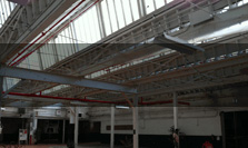
The former Phillips plant has five surviving detached industrial buildings and a former residence on an adjacent parcel that contribute to the site. The industrial buildings are located west of Research Drive. Except for an earlier office (Building 2, c.1890) and one block within the main production loft building (Building 1), the buildings appear to date from the period of Sterling ownership beginning in 1923. Building 1 is comprised of multiple adjoining blocks built between c.1890 and 1946. It replaced the plant’s earlier, smaller wood framed buildings, re-using some of the earlier rubble foundations at the building’s east end. Except for the two-story earliest existing block (tentatively dated c.1890), the Sterling-era construction is three-stories in height, with some additions above basements and some with small fourth story penthouses. The current building encloses about 134,200 square feet (excluding basements, loading docks and penthouses) arranged in a roughly-U-shaped plan around a railroad siding. The building expanded outward from its earliest block, a production loft identified as 'factory' in the 1920s on the north stub of the u-plan. The factory is 82 feet by 56 feet, with a loading dock built within its plan on its south elevation facing the rail siding. The load-bearing masonry building has brick walls trimmed with bluestone sills and lintels. South and east of this, the earliest Sterling-era portion was added as a free-standing building, consisting of an office head-house in the southeast corner with a production loft extending northward from its rear, terminating the rail siding. The head-house appears to have superseded the function of an earlier free-standing office (Building 2) closer to the road. The brick head-house façades have symmetrical fenestration and are architecturally distinct from the production loft exteriors. The south elevation has an elliptical arched entrance sheltered by a gable-roofed porch carried by paired wood columns centered on the first floor. Rectangular window openings above, five bays wide on the south and six bays deep on the east and west elevations, have cast stone lintels with keystones. The edge of the third floor slab is expressed as a belt course, and the parapet has inset cast stone diapers and raised brick and cast stone crests above the copings. There is also an arch-shaped parapet crest centered above a loading dock adjacent to the head-house. The crest enframes a round terra-cotta medallion with the Phillip’s logo in raised relief. The Sterling-era production blocks are typical reinforced-concrete frame daylight factory lofts with large expanses of steel windows and brick spandrels. The loft blocks at the east end of the plan were built by 1926. Those at the west end of the plan, which are connected by a third floor bridge spanning the rail siding entrance, were added in 1946. Building 2 is located east of Building 1 closer to Glenbrook Road. It originated as the plant’s office prior to the Sterling era and appears to date from around 1890. The 1-1/2 story, rectangular plan building measures 22 by 82 feet enclosing about 1,900 square feet on the ground floor. The building is built of load-bearing brick with rectangular masonry openings. The original entrance is on the south elevation, sheltered by a pent roof supported by wrought iron brackets. The building has a gable roof. In the Sterling-era the former office was used as a warehouse. It is now used as a house of worship. Building 3 is the power plant, probably constructed in 1946 to replace an earlier one displaced by the extension of Building 1. The single volume space of two stories in height with a flat roof is located north of Building 1. It measures approximately 51 feet by 48 feet in plan, enclosing about 2,200 square feet. The brick building with large original steel windows is set back in the northwest corner around its exterior chimney stack. Buildings 4 and 5 are small garages built in th
Exterior Material(s)
Structural System(s)
Roof Form
Roof Material
n/a
Power Source
Condition
Fair
Condition Notes
The main production/administration loft (Building 1) and power house buildings are in need of maintenance but in fair condition and largely occupied, with most original window openings retained, as well as much sash in the production lofts. A smaller warehouse building now used as a church is in good physical condition but fenestration has been changed. The former residence was rehabilitated as a commercial condominium and is in good condition and fully occupied.
- Property Information
-
Specific Location
Two legal parcels on the north side of Glenbrook Avenue consisting of (650 Glenbrook Road) totaling 4.28 acres at the west side of the properties near the New Canaan Branch of the New Haven railroad line. 666 Glenbrook Road is a former residence on a parcel across Research Drive.
Adjacent To
Exterior Visible from Public Road?
Yes
Parcel ID / Assessor Record Link
Acreage
4.28
Use (Present)
- Sources
-
Form Completed By
Wes Haynes
Date
September 2016
Bibliography
- Map of Fairfield County; Baker, William A., 1854.
- Plan of Stamford CT : Beers.
- Sanborn Map Co., 1926, 1929-30, 1951.
- 'Phillips Division to Expand,' New York Times, 1946.
- 'Backward Look,' New York Times, July 23, 1958.
- Gregg D. Mecca, Made in Stamford: A History of Stamford as a Manufacturing Center. Stamford, CT: Stamford Historical Society, 1984.
- Price & Lee’s Stamford (Fairfield County, Conn.) City Directory, New Haven, 1985.
- Representative View(s)Click on image to view full file
-


Photographer
n/a
Photography Date
September 2016