Mill Record Seymour
RETURN TO ‘FIND MILLS’Disclaimer: Content for these properties was compiled in 2014-2017 from a variety of sources and is subject to change. Updates are occasionally made under Property Information, however the Connecticut Trust for Historic Preservation (dba Preservation Connecticut) makes no representation or warranty that the information is complete or up-to-date.
- Complex Name (Common)
- Rimmon Mfg. Co.
- Complex Name (Historic)
-
- Rimmon Mfg. Co.
- Address or Location
- 16 Day Street, Seymour
- County
- New Haven
- Historic Designation
- Associated Mill Community
- n/a

- Historic Information
Companies Associated w/Complex
- Kerite Insulated Wire & Cable Co. ca. 1925-ca. 1950
- Rimmon Eyelet Co. 1907-ca. 1925
- Rimmon Mfg. Co. 1900-1907
- S. Smith Paper Co. 1866-1870
- Smith & Bassett Paper Co. ca. 1855-ca. 1866
- The Kerite Co. ca. 1950-Present (2015)
- W.W. Smith Paper Co. 1870-ca. 1890
Use (Historic)
Largest Documented Workforce
Unknown.
Historic Narrative
The site of the Rimmon Manufacturing Company’s mill in Seymour, Connecticut was first developed for industrial purposes during the middle of the 19th century. This consisted of a paper mill operated by the firm of Smith and Bassett that was erected ca. 1855, although, paper production had been conducted in the area by the Smith family since the beginning of the century. By the 1860s, sole control of the Smith and Bassett mill had passed into the hands of Reverend Seymour Smith, who in 1866 brought his son W.W. Smith into the business. W.W. Smith assumed full control of the company in 1870, and continued to oversee the manufacture of manila paper until the firm ceased operations around 1890. The paper mill stood vacant until 1900 when the plant was occupied by the newly-organized Rimmon Manufacturing Company. The Rimmon Manufacturing Company was founded by George E. Matthies, a director and assistant secretary at the Seymour Manufacturing Company, on January 10, 1900. The firm specialized in the manufacture of small brass items, most notably eyelets for shoes and corsets. Matthies was the company’s primary shareholder and served and its first president. The Rimmon Manufacturing Company was reorganized and incorporated as the Rimmon Eyelet Company in 1907. The business of the firm continued and substantial additions to the plant were completed in 1918, these likely in response to increased wartime demand for the company’s products. By 1925, however, the Rimmon Eyelet Company has ceased operations and its factory had passed to the Kerite Insulated Wire and Cable Company, a manufacturer of submarine, aerial, and underground electric cables with roots in Seymour dating back to 1854. Kerite maintained a substantial plant on the north side of Day Street and the firm both occupied and expanded the former Rimmon Eyelet Company throughout the mid-to-late-20th century. The manufacturer operated as the Kerite Insulated Wire and Cable Company until around 1950, after which it was identified simply as The Kerite Company; it continues to maintain its substantial Seymour plant.
- Architectural Information
Number of Existing Buildings
Roughly twelve (12) adjoining primary blocks.
Dates of Construction
ca. 1855, ca. 1905, 1918, ca. 1925, ca. 1940, 1960, ca. 1970.
Architect
n/a
Builder
n/a
Building Type
Architectural Description
The former Rimmon Manufacturing Company plant is comprised of roughly twelve primary adjoining blocks located on the south side of Day Street, at the southeast corner of Day Street’s intersection with Derby Street (CT Route 67) and on the north side of the Bladens River. The oldest portion of the plant was erected ca. 1855 and is a two-story, 72’ x 48’ wood-frame manufacturing block situated at the northwest corner of the complex. This has a concrete-parged brick foundation, vertical board siding, modern windows, and a side-gabled roof. A three-story, 42’ x 63’ wood-frame addition was erected adjoining the ca. 1855 block’s south elevation ca. 1905. The addition originally housed a press room and machine shop and it has vertical board siding, modern windows, and a side-gabled roof. A one-story, 35’ x 24’ wood-frame block links the press room and machine shop with a two-story, 55’ x 124’ red brick manufacturing building. Both the ell and the brick block were erected in 1918. The brick addition is the most highly detailed building associated with the plant. It is of brick mill construction and has large window openings with concrete sills, double-hung windows with five-over-five metal sash, and corbelled brick headers; a brick cornice with large brick corbels; and a flat roof. Substantial additions to the plant were completed during the mid-20th century. A three-story, 54’ x 120’ brick pier manufacturing block with large rectangular windows and a flat roof was erected adjoining the east elevation of the ca. 1905 building around 1940. The plant was expanded further eastward ca. 1960 through the addition of a massive one-story steel-frame, concrete, and red brick block. The latter has a frontage of roughly 430’ along Day Street and at its maximum is 122’ deep. The building has a concrete foundation, concrete piers, red brick apron walls, a concrete cornice, and flat roof. Metal ribbon windows extend along the building’s roofline and large metal lettering that reads, ‘THE KERITE COMPANY,’ stands atop the roofline of the north elevation. Further notable additions to the plant were completed ca. 1970, these consisting of two blocks adjoining the southeast corner of the ca. 1960 addition, and another linking its west elevation to the ca. 1855 mill.
Exterior Material(s)
Structural System(s)
Roof Form
Roof Material
Power Source
Condition
Fair
Condition Notes
The complex is in fair condition. Although several of the plant’s earliest blocks have had their exterior siding and windows replaced, overall, the remainder of the complex retains its historical integrity and appears to be structurally sound.
- Property Information
-
Specific Location
One legal parcel (16 Day Street) totaling 6.6 acres located on the south side of Day Street, at the southeast corner of Day Street’s intersection with Derby Street (CT Route 67) and on the north side of the Bladens River.
Adjacent To
Exterior Visible from Public Road?
Yes
Parcel ID / Assessor Record Link
- 10-10-70 / Link →
Acreage
6.6
Use (Present)
- Sources
-
Form Completed By
Lucas A. Karmazinas
Date
11/05/2015
Bibliography
- List of Connecticut Manufacturers, 1922, 1924, 1930, 1932.
- Directory of Connecticut State Manufacturers, 1936, 1939.
- Industrial Directory of Connecticut, 1947.
- Register of War Production Facilities in Connecticut, 1951.
- Map of New Haven County; Clark, Richard, 1859.
- Atlas of New Haven County, Beers, Ellis & Soule, 1868.
- Aerial Survey of Connecticut, 1934, 1965.
- Sanborn Map Company, 1884, 1890, 1895, 1900, 1906, 1911, 1924, 1949.
- Waterbury Directory; Various editions.
- History of Waterbury and the Naugatuck Valley, Connecticut, 1918.
- Tercentenary Pictorial and History of the Lower Naugatuck Valley, 1935.
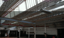
- Representative View(s)Click on image to view full file
-


Photographer
Lucas A. Karmazinas
Photography Date
11/05/2015