Mill Record Stafford
RETURN TO ‘FIND MILLS’Disclaimer: Content for these properties was compiled in 2014-2017 from a variety of sources and is subject to change. Updates are occasionally made under Property Information, however the Connecticut Trust for Historic Preservation (dba Preservation Connecticut) makes no representation or warranty that the information is complete or up-to-date.
- Complex Name (Common)
- Charles P. Bradway Machine Works
- Complex Name (Historic)
-
- Whiton Co.
- Charles P. Bradway
- Address or Location
- 169 West Stafford Road, West Stafford, Stafford
- County
- Tolland
- Historic Designation
- n/a
- Associated Mill Community
- n/a

- Historic Information
Companies Associated w/Complex
- Whiton Co. mid-19th c-1889
- C. P. Bradway Machine Works 1889-c.1965
Use (Historic)
Largest Documented Workforce
n/a
Historic Narrative
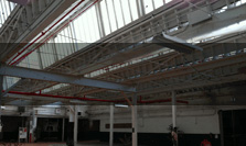
Documented by HABS in 1965, the mill was a small turbine driven machine shop dating from the mid-19th century. Initially owned by the Whiton Company (see entry for D. E. Whiton Machine Co. in New London opened c.1882), it was purchased by Charles P. Bradway in 1889 and occupied by the firm until at least 1965. At the time of the HABS survey, the mill still had the original 19th century equipment. Whiton made centering machines and lathe chucks. Bradway made water turbines and related equipment.
- Architectural Information
Number of Existing Buildings
One
Dates of Construction
Mid-19th century w/ later 19th century and c.1920 additions
Architect
n/a
Builder
n/a
Building Type
Architectural Description
Two story wood frame mill with first floor machine shop and second floor support shops (machine, woodworking and pattern). Original mill building, c mid-19th century, has two additions from third quarter of 19th century and one dated c.1920.
Exterior Material(s)
Structural System(s)
Roof Form
Roof Material
n/a
Power Source
Condition
n/a
Condition Notes
n/a
- Property Information
-
Specific Location
At rear of 1.46 acre parcel at the southwest corner of West Stafford Road (Rte. 190) and Krol Road.
Adjacent To
Exterior Visible from Public Road?
n/a
Parcel ID / Assessor Record Link
- 45/ / 117 / Link →
Acreage
1.46
Use (Present)
- Sources
-
Form Completed By
n/a
Date
4/2019
Bibliography
- Representative View(s)Click on image to view full file
-

Photographer
n/a
Photography Date
n/a