Mill Record Woodbury
RETURN TO ‘FIND MILLS’Disclaimer: Content for these properties was compiled in 2014-2017 from a variety of sources and is subject to change. Updates are occasionally made under Property Information, however the Connecticut Trust for Historic Preservation (dba Preservation Connecticut) makes no representation or warranty that the information is complete or up-to-date.
- Complex Name (Common)
- Daniel Curtiss & Sons
- Complex Name (Historic)
-
- Daniel Curtiss & Sons
- Address or Location
- 29 Pomperaug Road, Pomperaug, Woodbury
- County
- Litchfield
- Historic Designation
- Associated Mill Community
- n/a
 What can you do at this mill?
- Historic Information
Companies Associated w/Complex
- Daniel Curtiss & Sons ca. 1837-ca. 1905
Use (Historic)
Largest Documented Workforce
Unknown.
Historic Narrative
Daniel Curtiss was born in Woodbury on September 18, 1801. After completing public school in his home town he eventually traveled to New Jersey where he found work as a peddler. Around 1830 he returned to Woodbury and established a dry goods and grocery store. This venture met with considerable success and Curtiss reinvested the profits into a German silver shop, thus becoming the first manufacturer of this product in the Woodbury area. At its peak the firm employed as many as 75 peddlers selling a variety of plated wares including spoons, thimbles, and eyeglasses. This work continued until around 1840 when Curtiss sold the business to a manufacturer in Waterbury. After divesting himself of the silver shop, Curtiss established a woolen mill on the west side of the Pomperaug River in the Pomperaug section of Woodbury. By 1845, this factory was the largest of five textile mills in town and Curtiss had been joined in the business by his three sons, Walter S., Horace D., and Edward J. Curtiss, thus forming the firm of Daniel Curtiss and Sons. This company continued to grow and diversify over the course of the next three decades and by 1874 included a variety of structures flanking both sides of the river. In addition to the woolen manufactory, these included a flour, feed, and grain mill on the Pomperaug’s eastern bank, and a saw mill located on the river’s western side. Curtiss’ holdings in the area also included roughly a dozen employee tenements, which were located on both sides of the road running west from the mills. Daniel Curtiss died on May 16, 1878, after which the family business was organized and continued as Daniel Curtiss’ Sons. The woolen mill remained in operation through the early 1900 and as late as 1903 was noted as working at maximum capacity on day and night shifts. Two years later, however, a devastating fire completely destroyed the adjoining woolen and saw mills on the west side of the river. Although this was not the first time that the plant had burned, the decision to discontinue the business was made after surveying the damage. The buildings that formerly housed the firm’s flour, feed, and grain mill were not impacted by the blaze, however, it does not appear that the company maintained operations along the Pomperaug after 1905.
- Architectural Information
Number of Existing Buildings
Roughly five (5) adjoining primary blocks.
Dates of Construction
ca. 1837, mid-to-late-19th c., ca. 1940, late-20th c.
Architect
n/a
Builder
n/a
Building Type
Architectural Description
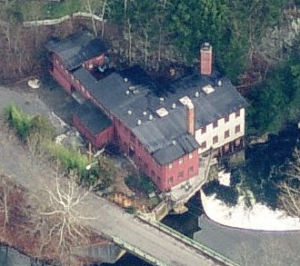
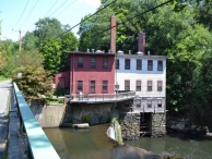
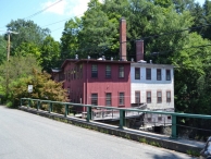
The former Daniel Curtiss and Sons flour, feed, and grain mill is the only industrial structure associated with the firm that appears to be extant. The mill is comprised of five primary adjoining blocks located on the south side of Pomperaug Road and along the east bank of the Pomperaug River. The building’s stone foundation forms the eastern abutment of a stone dam that spans the river, formerly providing power to the milling operations once located on both sides of the river. The core of the mill is a two-story, 32’ x 64’ wood-frame block erected ca. 1837. This has a stone block foundation, a partial basement level below its southern half, vertical board and wood shingle siding, 12-over-12 double-hung wood windows with plain wood surrounds, and a low-pitch front-facing gable roof. Two-story wood-frame ells were erected adjoining the east and west elevations of the original block at some point during the mid-to-late-19th century. These measure roughly 16’ x 28’ and 24’ x 34’ respectively and have vertical board siding and 12-over-12 double-hung wood windows with plain wood surrounds. The western ell has a shed roof, while that on the east side of the main block has a low-pitch side-gabled roof. The fourth block associated with the mill is a one-story, 24’ x 10’ wood-frame ell with a shed roof erected on the north side of the eastern addition ca. 1940. This has vertical board siding and small three-light windows. The final addition to the plant is a two-story, roughly 40’ x 18’ wood-frame block built on the east side of the mill during the late-20th century. This mimics the details of the earlier structures and has both front-facing and side-gabled roof sections. A large garage space with wood sliding doors is located at the ground level of the façade (north elevation), while 12-over-12 double-hung wood windows with plain wood surrounds extend across the upper story.
Exterior Material(s)
Structural System(s)
Roof Form
Roof Material
Power Source
Condition
Good
Condition Notes
The complex is in good condition. Although some areas of the exterior wall cladding are in need of maintenance the mill appears to be well maintained overall.
- Property Information
-
Specific Location
One legal parcel (29 Pomperaug Road) totaling 0.73 acres located on the south side of Pomperaug Road and along the east bank of the Pomperaug River.
Adjacent To
Exterior Visible from Public Road?
Yes
Parcel ID / Assessor Record Link
- 034-005 / Link →
Acreage
0.73
Use (Present)
- Sources
-
Form Completed By
Lucas A. Karmazinas
Date
08/04/2015
Bibliography
- List of Connecticut Manufacturers, 1922, 1924, 1930, 1932.
- Directory of Connecticut State Manufacturers, 1936, 1939.
- Industrial Directory of Connecticut, 1947.
- Register of War Production Facilities in Connecticut, 1951.
- Map of Litchfield County; Clark, Richard, 1859.
- Atlas of Litchfield County, F.W. Beers & Co., 1874.
- Aerial Survey of Connecticut, 1934, 1965.
- History of Litchfield County, Connecticut; Lewis, J.W. & Co., 1881.
- Around Woodbury; Chesson, Frederick W., 2000.
- Representative View(s)Click on image to view full file
-


Photographer
Lucas A. Karmazinas
Photography Date
08/04/2015