Mill Record Montville
RETURN TO ‘FIND MILLS’Disclaimer: Content for these properties was compiled in 2014-2017 from a variety of sources and is subject to change. Updates are occasionally made under Property Information, however the Connecticut Trust for Historic Preservation (dba Preservation Connecticut) makes no representation or warranty that the information is complete or up-to-date.
- Complex Name (Common)
- Fort Griswold Paper Co.
- Complex Name (Historic)
-
- Fort Griswold Paper Co.
- Address or Location
- 469 Route 163, Montville
- County
- New London
- Historic Designation
- Associated Mill Community
- n/a

- Historic Information
Companies Associated w/Complex
- C. M. Robertson 1886
- Federal Paper Board Co.
- Fort Griswold Paper Co
- Inland Paper Board Co.
- Rockland Paper Co. 1871-1886
Use (Historic)
Largest Documented Workforce
n/a
Historic Narrative
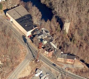
Above Rockland's pond is the so-called Wheeler privilege, one of the oldest developed sites on the Oxoboxo and the site of the largest impoundment below the reservoir. A sawmill operated here from 1700 to 1813, a machine shop from 1813 to 1817. and cotton mills from 1837 to 1871, after which Rockland Paper Co. ran the mills for 15 years. C. M. Robertson bought the property in 1886 and erected a stone mill for his paper manufacture. (Roth)
- Architectural Information
Number of Existing Buildings
n/a
Dates of Construction
n/a
Architect
n/a
Builder
n/a
Building Type
n/a
Architectural Description
The 1886 mill is an ell-shaped, 1-story mill with random coursed granite walls and a gable roof topped by a low monitor. Another stone mill and two brick additions also stand, as does the earth and masonry dam. (Roth)
Exterior Material(s)
Structural System(s)
n/a
Roof Form
Roof Material
n/a
Power Source
n/a
Condition
Deteriorated
Condition Notes
historic mill fabric looks to be largely fallen down
- Property Information
-
Specific Location
between the Oxoboro Brook to the east and Route 163 to the west, across from Maple Avenue
Adjacent To
Exterior Visible from Public Road?
Yes
Parcel ID / Assessor Record Link
- 031/ 010/ 000 (for record, use link and type in address or parcel number) / Link →
Acreage
112.01
Use (Present)
- Sources
-
Form Completed By
n/a
Date
n/a
Bibliography
- Roth, Matthew, et al, Connecticut: An Inventory of Historic Engineering and Industrial Sites (Washington DC: SIA, 1981).
- Representative View(s)Click on image to view full file
-
Photographer
n/a
Photography Date
n/a