Mill Record New Hartford
RETURN TO ‘FIND MILLS’Disclaimer: Content for these properties was compiled in 2014-2017 from a variety of sources and is subject to change. Updates are occasionally made under Property Information, however the Connecticut Trust for Historic Preservation (dba Preservation Connecticut) makes no representation or warranty that the information is complete or up-to-date.
- Complex Name (Common)
- Gillette Grist Mill
- Complex Name (Historic)
-
- Gillette Grist Mill
- Address or Location
- 151 Maple Hollow Road, New Hartford
- County
- Litchfield
- Historic Designation
- Associated Mill Community
- n/a

- Historic Information
Companies Associated w/Complex
Use (Historic)
Largest Documented Workforce
n/a
Historic Narrative
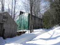
see National Register nomination Gillette Grist Mill stands on the west bank of the Nepaug River. Because this mill represents 19th-century technology which rarely survives, even in this deteriorated condition, it was recorded in 1977 by a survey team from the Southern New England Chapter, Society for Industrial Archaeology. The survey findings have had significant impact on the waterwheel reconstruction project at Slater Mill Historic Site, Pawtucket, RI. (Roth)
- Architectural Information
Number of Existing Buildings
1
Dates of Construction
mid-19th c.
Architect
n/a
Builder
n/a
Building Type
Architectural Description
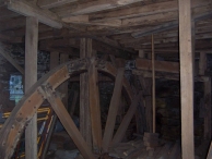
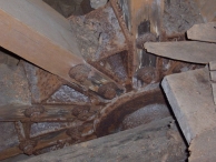
Set on a deep foundation/wheel pit of mortared rubble, it is a 2-story frame building with gable roof. The earthen and rubble-walled headrace, leading from the ruins of a dam upstream, is mostly filled in. The underground masonry tailrace discharged into the stream about 40' below the mill. The mid-breast wheel is about 18' diameter and 6' across the face. The buckets and much of the felloes have rotted away but extant fragments of the felloes have mortises where the buckets were fitted, and from which the size, shape, and location of the buckets can be determined. The axle is iron, as is the hub, which held the heavy wooden spokes. Iron rods tie the two sides of the wheel together at the spoke ends. On one side of the wheel the felloe is extended toward the wheel's center, and this extension carries a cast iron internal ring gear which provided power take-off through a pinion gear. The round shaft carrying this pinion holds a bevel gear at its other end, which meshes with another bevel gear to drive the polygonal vertical shaft that drove the spindles for the stones. All these parts are iron, except for the wooden teeth in the bevel gear on the vertical shaft. Little survives on the first floor of the mill. On the second fIoor are found a bolter and a smutter. along with the overhead, square-section shafting which drove them. (Roth)
Exterior Material(s)
Structural System(s)
Roof Form
Roof Material
n/a
Power Source
Condition
n/a
Condition Notes
n/a
- Property Information
-
Specific Location
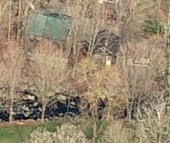
5.6 acre parcel on the north side of Maple Hollow Road and the Nepaug River, north of the Dings Road intersection.
Individually listed on the National Register of Historic Places,Adjacent To
Exterior Visible from Public Road?
Yes
Parcel ID / Assessor Record Link
- 015-028-18A (for record, use link and type in address or parcel number) / Link →
Acreage
5.6
Use (Present)
- Sources
-
Form Completed By
n/a
Date
2011
Bibliography
- Roth, Matthew, et al, Connecticut: An Inventory of Historic Engineering and Industrial Sites (Washington DC: SIA, 1981).
- Clouette, Bruce. 1977. Gillette's Gristmill National Register Nomination No. 77001403. National Park Service.
- Gillette's Grist Mill record. 2011. Historic Barns of Connecticut.
- Representative View(s)Click on image to view full file
-


Photographer
CTHP
Photography Date
2011