Mill Record Montville
RETURN TO ‘FIND MILLS’Disclaimer: Content for these properties was compiled in 2014-2017 from a variety of sources and is subject to change. Updates are occasionally made under Property Information, however the Connecticut Trust for Historic Preservation (dba Preservation Connecticut) makes no representation or warranty that the information is complete or up-to-date.
- Complex Name (Common)
- Pequot Mills (wool)
- Complex Name (Historic)
-
- Pequot Mills (wool)
- Address or Location
- 152 Route 163, Montville
- County
- New London
- Historic Designation
- Associated Mill Community

- Historic Information
Companies Associated w/Complex
- Brothers and Crosby 1860-
- J. B. Martin Co. 1919-1941
- Norton and Blackstone 1871-
Use (Historic)
Largest Documented Workforce
130 (1896)
Historic Narrative
At the third privilege [on the Oxoboxo River], are the ruins of the Pequot Mills, formerly the site of a sawmill in the 18th century and an oil mill from 1803 to 1860. Three investors from Norwich bought the oil mill in 1860, enlarged it, added more buildings and produced woolen cloth. As of 1896, the factory produced print cloth on 238 looms with 8,064 spindles and employed 130. (Roth) Norton Brothers and Hiram Crosby of Norwich transformed the old oil mill into a woolen mill. In 1871, having been transferred to Henry B. Norton and Lorenzo Blackstone, production was switched to cotton. When J. B. Martin Co. took over the mill, production was changed again, to silk.
- Architectural Information
Number of Existing Buildings
Roughly three (3) blocks.
Dates of Construction
c.1860, c.1877
Architect
n/a
Builder
n/a
Building Type
Architectural Description
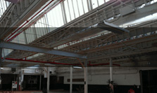
The random-coursed stone walls of a 2-story mill, about 100' x 5-', stand on the east bank of the river. Next to it is a 1-story, brick mill, about 280' x 50' with near-flat roof, segmental-arch lintels and stone sills; this mill was probably built in 1877 when production changed from woolens to cottons. On the west bank are foundations and some walls of a stone, random-coursed, 2-story mill, about 70' x 30'; of a windowless, rubble-walled storehouse, about 60' x 50'; and of several smaller structures. The dam is about 35' high and consists of earth embankments with a stepped, masonry spillway. From the west abutment a penstock runs about 30' downstream to the wheelpit of what was the powerhouse, below which the penstock crosses the stream and goes underground to the mills on the east bank. This two-stage system, with 52' total fall, was built in 1877. West of the mills are five double-entry frame dwellings and three with single entry; all have two floors and gable roofs. (Roth)
Exterior Material(s)
Structural System(s)
Roof Form
Roof Material
n/a
Power Source
n/a
Condition
n/a
Condition Notes
n/a
- Property Information
-
Specific Location
Two parcels totaling 3.91 acres on the west side of route 163, along the Oxoboro Brook and Pequot Road.
Individually listed on the State Register of Historic Places.Adjacent To
Exterior Visible from Public Road?
Yes
Parcel ID / Assessor Record Link
- 072-054-00A (for record, use link and type in address or parcel number) / Link →
- 072/ 054/ 00C (for record, use link and type in address or parcel number) / Link →
Acreage
2.8; 1.11
Use (Present)
- Commercial
- Other: For sale 1/2023
- Sources
-
Form Completed By
n/a
Date
n/a
Bibliography
- Baker, Henry A., A History of Montville (1896).
- Chase, Jon B. Images of America: Montville (Arcadia Publishing: 2004).
- Roth, Matthew, et al, Connecticut: An Inventory of Historic Engineering and Industrial Sites (Washington DC: SIA, 1981).
- State Register Nomination on file at office of SHPO, Hartford CT.
- Representative View(s)Click on image to view full file
-

Photographer
n/a
Photography Date
n/a