Mill Record Norwalk
RETURN TO ‘FIND MILLS’Disclaimer: Content for these properties was compiled in 2014-2017 from a variety of sources and is subject to change. Updates are occasionally made under Property Information, however the Connecticut Trust for Historic Preservation (dba Preservation Connecticut) makes no representation or warranty that the information is complete or up-to-date.
- Complex Name (Common)
- Remington Rand Corp.
- Complex Name (Historic)
-
- Remington Rand Corp.
- Address or Location
- 333 Wilson Avenue, South Norwalk, Norwalk
- County
- Fairfield
- Historic Designation
- Associated Mill Community
- n/a

- Historic Information
Companies Associated w/Complex
- Remington Rand Corp. 1927-1955
- Sperry Rand Co. 1955-1975
Use (Historic)
Largest Documented Workforce
300 (1946).
Historic Narrative
The Remington Rand Company was formed in 1927 as the result of a merger between the Remington-Noiseless Typewriter Company, an office machine and personal products manufacturer, and Rand Kardex, an office equipment company. Remington Rand operated numerous plants throughout the country, including several in Bridgeport and Middletown, Connecticut, and the firm produced a variety of typewriters and other office machines through the 1930s and 1940s. During the early 1940s, the company acquired several properties in Norwalk, Connecticut, including the former Farrell estate in the Rowayton section of the city, and a property at 333 Wilson Avenue in South Norwalk. The former was converted into the company’s corporate headquarters, while the later served as the site for a new modern typewriter factory and research and development lab, this constructed in 1945. In 1943, engineers at Remington Rand began work on the Remington Rand 409, a device that would become the world’s first successful mass-marketable business computer. The idea had been pitched to James Rand, the founder chairman, and president of Remington Rand by an engineer by the name of Loring P. Crosman, who soon found himself leading up a team of engineers located at the firm’s Brooklyn, New York headquarters. Shortly after the conclusion of the Second World War, the work was moved to an improvised and top secret research facility located in a former stable on the grounds of the Farrell estate known as ‘The Barn,’ and in 1948 management of the project felt under the jurisdiction of retired Army General Leslie R. Groves, former director of the Manhattan Project, who established a second team under Joseph A. Brustman to work in parallel with Crosman’s engineers. By 1949, the two teams had successfully designed a functional version of the 409 and manufacturing of preproduction components had begun. This work was completed in 1951 when the prototype was revealed to a group of military and government officials. The reception was favorable and the first delivery of the 409 was made to the Internal Revenue Service in 1952, which quickly placed orders for two more of the machines. Once the secrecy of the 409 project was no longer necessary, the engineers who had worked on the device were transferred to the main research and development lab at 333 Wilson Avenue. This facility was considerably enlarged through the construction of three additional buildings during the early 1950s, which brought the total size of the complex to over 150,000 square feet. In 1955, Remington Rand merged with the Sperry Corporation to form Sperry Rand, which maintained research and development operations in Norwalk until 1975. The facility then became the first home of Norwalk Community College. This use continued until the college moved to West Norwalk in 1991. The building then fell vacant until it was converted for office use in 2005.
- Architectural Information
Number of Existing Buildings
Two (2) freestanding primary blocks.
Dates of Construction
1945, 1952.
Architect
Fletcher Thompson Inc.
Builder
n/a
Building Type
Architectural Description
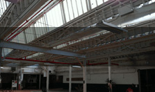
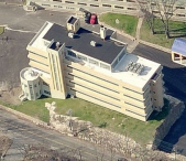
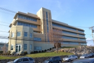
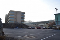
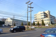
The former Remington Rand facility is comprised of two primary freestanding buildings located on the west side of Wilson Avenue, at the northwest corner of Wilson Avenue’s intersection with Grey Rock Road. The original and most prominent structure is a four-story, 204’ x 62’ Art Moderne style building erected in 1945. The building is of steel-frame construction and has a concrete foundation with partially raised basement level; yellow brick apron walls; long wrap-around ribbon windows with rectangular openings, concrete sills and lintels, and metal sash; cantilevered concrete window hoods, concrete copings, and a flat roof. Five-story, rectangular, yellow brick stair towers with full-heigh window bays and concrete parapets are located on the east and west (front and rear) elevations of the building; while a two-story dodecagonal entry pavilion is situated at the block’s southeast corner. The latter is of poured concrete construction and has a flat roof. Its concrete piers and parapet are decorated with embossed floral patterns, while the wall panels bear fluting between the first and second floors. The main entry consists of a pair of metal and glass doors set below a simple metal and glass transom. The second building associated with the facility is a three-story, 300’ x 80’ steel-frame and concrete block erected in 1952. The second building stands roughly 125’ west of the 1945 block. The 1952 building has a concrete foundation, concrete wall panels, rectangular window openings with concrete sills formed by concrete stringcourses on all three floors, and a side-gabled roof. A gabled clerestory monitor extends the full length of the block’s roof.
Exterior Material(s)
Structural System(s)
Roof Form
Roof Material
Power Source
Condition
Good
Condition Notes
The complex was rehabilitated in 2005 and is in excellent condition, although the 1952 building has undergone extensive non-historically sympathetic alterations to its walls and windows.
- Property Information
-
Specific Location
One legal parcel (333 Wilson Avenue) totaling 4.29 acres located on the west side of Wilson Avenue, at the northwest corner of Wilson Avenue’s intersection with Grey Rock Road.
Adjacent To
Exterior Visible from Public Road?
Yes
Parcel ID / Assessor Record Link
- 5/83/68/0. / Link →
Acreage
4.29
Use (Present)
- Sources
-
Form Completed By
Lucas A. Karmazinas
Date
11/06/2015
Bibliography
- List of Connecticut Manufacturers, 1922, 1924, 1930, 1932.
- Directory of Connecticut State Manufacturers, 1936, 1939.
- Industrial Directory of Connecticut, 1947.
- Register of War Production Facilities in Connecticut, 1951.
- Map of New Haven County; Clark, Richard, 1859.
- Atlas of New Haven County, Beers, Ellis & Soule, 1868.
- Aerial Survey of Connecticut, 1934, 1951, 1965, 1970, 1985.
- Sanborn Map Company, 1891, 1896, 1901, 1906, 1922, 1950, 1958.
- Norwalk Directory; Various editions.
- Hartford Courant, 1945, 1954.
- New York Times, 1998.
- Rowayton Historical Society website.
- Norwalk; Grant, Lisa Wilson, 2014.
- Representative View(s)Click on image to view full file
-
Photographer
Lucas A. Karmazinas
Photography Date
11/06/2015