Mill Record Plainfield
RETURN TO ‘FIND MILLS’Disclaimer: Content for these properties was compiled in 2014-2017 from a variety of sources and is subject to change. Updates are occasionally made under Property Information, however the Connecticut Trust for Historic Preservation (dba Preservation Connecticut) makes no representation or warranty that the information is complete or up-to-date.
- Complex Name (Common)
- Almyville Mill
- Complex Name (Historic)
-
- Almyville Mill
- Address or Location
- 378 North Main Street, Almyville, Plainfield
- County
- Windham
- Historic Designation
- Associated Mill Community

- Historic Information
Companies Associated w/Complex
- Almyville Mill 1879
- American Woolen Co. 1899-1929
- Milner and Co. 1889-1899
Use (Historic)
Largest Documented Workforce
n/a
Historic Narrative
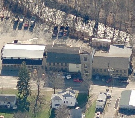
Almyville was named for William Almy, who built a woolen mill at the lower privilege on the Moosup River in 1816. Almy interests produced woolens here until fire destroyed the mill in 1875. David Aldrich and Edwin Milner, woolen manufacturers from Rhode Island, built a new mill in 1879. After Aldrich died in 1889 Milner reorganized the firm as Milner and Co. In 1891 he built the Glen Falls Mill (now demolished) about one-half mile upstream; this 2-story mill, 260' x 75' with a 75' x 65' wing, had random-coursed stone walls and granite trim, near-flat roof with five raised skylights. Milner used Glen Falls Mill for carding and weaving, with 17 sets of cards and 85 broadlooms operated by about 275 workers. American Woolen Co. bought the mills in 1899. Under American Woolen all carding and spinning were done at the lower mill and all weaving at Glen Falls. The mills ran until 1929 and were sold in 1932. The lower mill is now tenanted and Glen Falls is owned by Brunswick Worsted Mills, Inc. There are some 60 workers' dwellings in Almyville; most are double-entry frame houses with gable roofs. The dam at Glen Falls was built some 10 years before the mill; it is a curved gravity dam, made of stone blocks, 18' high with a stepped spillway. The lower dam is gone but the power canal that it fed remains. Now mostly dry, the rubble-walled canal is about 6' deep, 7' wide and 1700' long. (Roth)
- Architectural Information
Number of Existing Buildings
Three (3) primary blocks.
Dates of Construction
1879, c.1880s
Architect
n/a
Builder
n/a
Building Type
n/a
Architectural Description
The 3-story rubble-stone mill, about 100' x 50', has a gambrel roof with trap-door monitor and a corner stair tower; it was originally some 60' longer and one story higher. Sills, lintels, and quoins are made of granite. Additions with similar walls and trim were built to the east and west in the early 1880s. (Roth)
Exterior Material(s)
Structural System(s)
n/a
Roof Form
Roof Material
n/a
Power Source
n/a
Condition
n/a
Condition Notes
n/a
- Property Information
-
Specific Location
One 3.1 acre parcel on the south side of North Main Street west of Lake Street intersection
Adjacent To
Exterior Visible from Public Road?
Yes
Parcel ID / Assessor Record Link
- 4M/108/17 / Link →
Acreage
3.10
Use (Present)
- Sources
-
Form Completed By
n/a
Date
n/a
Bibliography
- Roth, Matthew, et al, Connecticut: An Inventory of Historic Engineering and Industrial Sites (Washington DC: SIA, 1981).
- Representative View(s)Click on image to view full file
-

Photographer
n/a
Photography Date
n/a